Type E Complexes and the agricultural calendar: “Group E” clusters—western platforms and east-aligned structures—form an integrated stone agricultural calendar within the Maya urban fabric. These complexes were not isolated observatories: their central axes (west-east) and side alignments were arranged to mark important dates in the agricultural cycle (not just solstices or equinoxes). Šprajc (2021) confirms that the orientation of the E Groups belongs to “broad alignment groups” linked to the fundamental concerns of the agricultural society rather than to specific observations. In practice, the axes of the E Groups mark the sunrise at important moments—for example, marking the 143-day intervals between March 2 and October 10—and these intervals are consistent with seasonal agricultural activities.

Statistical studies of the alignments show that they are grouped at equally spaced dates related to 13 and 20 days (important periods in the Maya calendar), rather than focusing solely on the equinoxes. Consequently, E Groups served as ritual stages representing the solar calendar – a symbolic “theater” for the agricultural cycle rather than a precise measuring instrument. For example, at Uaxactún, Tikal, or Ceibal, offerings and tombs aligned with the central axis of the E Groups were found, while the side platforms changed over time. Thus, the Maya agricultural calendar is “embodied in stone” through urban complexes oriented to regulate rituals related to planting and the solar year.
- Case studies: Uaxactún (Group E), Tikal (Lost World E), Ceibal (Central), compared with patterns at Chichén Itzá (Postclassic).
- To be measured: Azimuths of the axes (±0.25°), local horizon height, relevant solar dates, intervals between dates (multiples of 13/20 days).
- Methods: Topographic measurements/LiDAR of architectural axes; calculations of sunrise and sunset based on latitude and duration of use; statistical analysis of alignments according to the agricultural calendar.
Zenith passages and light architecture: In the Maya region, the sun’s zenith passages (the moment when the sun is at its zenith at noon, casting no shadows) influenced the design of openings, skylights, and internal layouts. Rooms with vertical light shafts or cave modifications that allowed sunlight to enter at specific times during the day have been found. For example, at Monte Albán (Building P) and Teotihuacán, there are records of sunlight entering interior niches on important dates, supported by the orientation of the buildings. Šprajc (2018) states that observing the zenith sun was not the “main function” of these areas, but rather one of their functions, with light entering ritually on important dates.
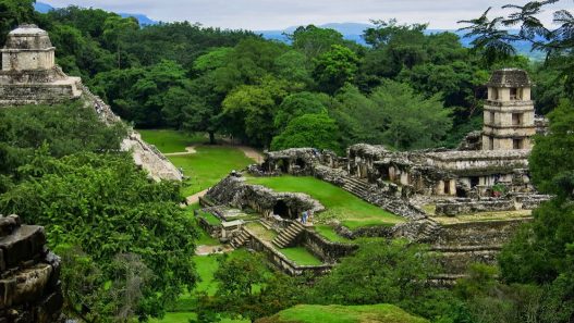
The Sun Room at Palenque: The Palace Tower at Palenque (Grupo de las Cruces) exemplifies this principle. Anderson et al. (1981) documented that on August 12 (a few days after the local zenith passage), sunlight entered vertically through the T-shaped window on the west wall without casting a shadow on the interior wall. This demonstrates that the aperture was oriented with extreme precision to record the zenith and solstice passages. Such “zenithal windows” and high windows (like those at the top of temples) function like internal sundials: by modeling the sun’s orbit with 3D software, it can be verified that direct sunlight reaches these areas on significant dates, extending the “shadowless” period for minutes or even hours.
- Case studies: Palenque (Palace Tower, Cross Group), temples with roof windows or chimneys found in various locations.
- To be measured: Aperture heights, light well diameters, angles of incidence of sunlight for zenith dates, duration of direct illumination in interior rooms.
- Methods: Architectural sections using solar simulation (clockwise); on-site recording of light/shadow penetration in interior cameras.
Performative solar phenomena (urban rituals): Maya architecture choreographed light and shadow displays that have evolved into urban rituals today. The most symbolic example is the descent of the light serpent seen at the Kukulkán pyramid (El Castillo) in Chichén Itzá. At the equinoctial sunset, the light forms luminous triangles resembling the tail of a mythological serpent. Similarly, at Dzibilchaltún (Yucatán), the Temple of the Seven Children is cut by the equinoctial sun through its east-west windows, a phenomenon popular in equinoctial imagery. These effects lead to processions and mass gatherings in plazas and along ceremonial roads (sacbeob) on specific dates.
However, recent research has shown that these events are not entirely related to the equinox and are not limited to a single day. For example, at Dzibilchaltún, the temple’s axial orientation is ~1° off true east, so “iconic” equinoctial photos can be taken a few days before or after. At Chichén Itzá/Mayapán, the illuminated triangles are visible for weeks during the solstices, and their number changes. In summary, light journeys and rituals (e.g., the descent of the serpent god in March/September) regulate and confirm the astronomical purpose of the buildings, but archaeoastronomers note that solstices and equinoxes were not necessarily fundamental dates in Mesoamerica. Directions marked the sunrise/sunset on various agricultural dates, and the effects of light extended beyond the exact moment. Thus, urban architecture transformed solar events into civic spectacles as the sun passed over plazas and sacbéos, but their ritual meaning was tied not only to astronomical simulations but also to the agricultural calendar.
- Case studies: Chichén Itzá (Kukulkán serpent), Dzibilchaltún (Temple of the Seven Babies), Mayapán (similar effect on the northern pyramid), light phenomenon laboratories; central plazas with solstice alignments at Uaxactún or Tikal.
- To be measured: Photo sequences that change over time on important days (rays/shadows per minute); width and direction of ray beams; accuracy of framing on stairs; visibility from sacbé for a wide audience.
- Critical observations: Research emphasizes that so-called “equinox phenomena” may occur during this period and are not necessarily specific to equinox designs. The social significance of the sun (“People’s Time”) is reflected in light passage ceremonies in squares and temples, but these ceremonies are interpreted in terms of the agricultural calendar and political power.
Hydrology, seasonal climate, and urban planning
The Maya built water infrastructure that combined water supply, politics, and rituals by organizing their city planning according to the climate seasons. In the lowland regions, where rains were seasonal and winters were dry, reservoirs, canals, and dams were vital for ensuring water supply during periods of drought. For example, a complex hydraulic system was designed in Edzná (Campeche): 13 main canals, 31 branches, and 84 reservoirs drained the flood-prone valley into a dammed lake, irrigating agricultural fields. This system allowed for the storage of rainwater, the drainage of flooded areas, and the development of intensive agriculture..

Zeolite acts as a natural filter for drinking water. Significant evidence has been found in Tikal (Guatemala): in the Corriental reservoir, there is a stratigraphic mixture of volcanic zeolite and natural quartz used as a drinking water filter. XRD analysis confirms that between 2200 and 1000 BC, water was purified using clinoptilolite and mordenite (zeolites) embedded in the filter, confirming this as the oldest known purification system in the Americas. In fact, the Maya imported volcanic sand (quartz) and zeolite from dozens of kilometers away to build these filters (the Corriental reservoir was ~58,000 m³ in size and supplied water to tens of thousands of people). As a result, no pollution or algae blooms were observed in the Corriental reservoirs, and the Maya kings legitimized their power by constructing these water structures alongside their palaces and temples.
Civil integration: Water structures were also used as civic plazas. In Caracol (Belize), the main monumental water reservoirs were located at the edge of the sacbés in the city center, without obstructing access, indicating that water was managed collectively. Over time, domestic water reservoirs emerged in neighborhoods alongside public water reservoirs. The Maya also managed water quality with “artificial wetlands”: they planted aquatic plants (water lilies, reeds) that filtered nutrients and oxygenated the water. This water retention system functioned for over 1,000 years until it ceased to operate due to the extreme droughts of 800-900 AD.
- Case studies: Tikal (Corriental reservoirs, zeolite filtration), Edzná (canals, dams, and artificial lakes), Caracol/Uxul (residential and public water networks).
- To be measured: The usable volume of reservoirs (m³), water collection area and seasonal renewal rates, XRD analysis of filtered sediments, past microbiological quality of water, spatial relationship with temples/palaces.
- Current applications: In countries such as Mexico and Peru, Mayan principles are being reintroduced: Mérida/Campeche uses depression parks and urban ponds to store rainwater; in Lima/Cusco, water storage courtyards and “sponge squares” that mitigate seasonal river flooding are reappearing. As highlighted by Lucero (2023), Maya artificial wetland techniques (aquatic plants, removable sediments, natural refilling) offer valuable lessons in sustainable water management.

Planetary Cycles and the Vision of Citizenship
During the Postclassic period, the observation of Venus and the Moon gained significance in architecture and rituals. Venus, associated with war and prophecy, began to be incorporated into large-scale architecture. For example, El Caracol at Chichén Itzá (also known as the “Observatory”) is a circular tower with strategically placed windows. Research shows that the windows on the second floor point to the azimuths of Venus’s extreme points at dawn and dusk. On the facade, there are reliefs related to Venus’s position and a disk inscribed with the glyph “K’uk’ Ek'” (“quetzal star,” Venus), along with figures with feathered serpent heads. Everything indicates that the observation of Venus at Chichén Itzá supported the emergence of Kukulkan as a true god. The Mayan inscriptions also mention the “K’uk’ Ek'” site in Palenque, which is associated with ritual Venus. These alignments reflect Venus’s synodic cycle (584 days) documented in the Venus Table in the Dresden Codex.
- Case studies: Epigraphic records at El Caracol (Chichén Itzá), Mayapán, and Palenque.
- To be measured: Angle of view relative to Venus’s maximum/minimum positions and the moon’s extreme points, frequency of occurrence (every 8 years, 18.6-year cycles, lunar cycle), observation time intervals.
- Methods: Reconstruction of window and slit alignments using simulation software, correlation with the Dresden Codex (Venus Table) dates and lunar cycles, relevant relief and iconography analyses.

When viewed as a whole, this situation brings to mind a complementary concept of “civil time”: the Maya had intertwined the rhythms of the planets with the public sphere. While solar calendars determined agriculture, Venus determined the rhythms of war and ritual (for example, in the Maya, military tensions increased every eight years, coinciding with the appearance of Venus). This approach suggests an urban planning that integrates the cosmos into politics. Today’s lesson is to acknowledge that societies can develop collective projects based on broader astronomical patterns, in addition to annual climate cycles (sun and rain).


