
Flood resilience begins with a clear understanding of the risks. It is not the dramatic hurricane footage constantly shown on television, but the quieter, more frequent events that shape coastal life. Since 2000, high tidal flooding has increased exponentially along the southeastern and Gulf coasts of the United States, disrupting daily transportation, straining drainage systems, and eroding buried infrastructure. This is a new baseline condition that architects must consider when designing, because tides are becoming increasingly extraordinary.
Resilience is not a single object or detail. It is a system of choices tailored to local hazards. In places like South Florida, complex flood events involving storm surges, heavy rains, and high tides are common. Understanding these interactions changes where we place critical rooms, where we put power and data sources, and how we think about exits and access during and after an event.

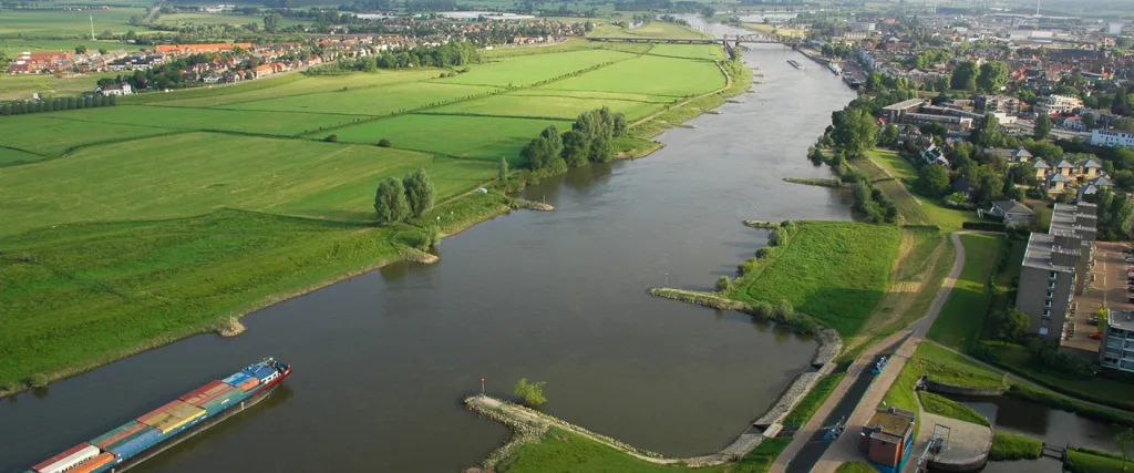
Florida is a good example in this regard. Its flat topography and porous limestone allow seawater to enter underground pipes during high tides. Standard defense systems, such as levees or simple sea walls, cannot stop the water flowing underneath them. Flooding on sunny days is not an exception here; it is part of a seasonal pattern that affects streets, infrastructure, and buildings.
Understanding the Threat: Flooding in Coastal Areas
Coastal risk combines long-term trends and short-term shocks. Sea levels are rising due to thermal expansion caused by ocean warming and the addition of meltwater from glaciers and ice sheets. The IPCC reports a significant increase in the rate of sea level rise and predicts substantial increases by 2100 unless strong measures are taken. These background changes are elevating the platform affected by storms.

Keren Bolter
Short-term hazards include storm surges, heavy rainfall, and high tidal floods. During storms, waves can push water inland. Heavy rainfall can overload urban drainage systems even far from rivers. High tides can leave streets underwater even if there is not a single cloud in the sky. Each mechanism has different footprints and time scales, so hazard-specific mapping and modeling are crucial for site selection, structure, and material choices.

Designers also work within a risk economy. The frequency and cost of billion-dollar disasters have increased, and tropical cyclones stand out as the most costly hazard in the United States. Flooding is not just a problem for coastal regions, but when storms and rising sea levels combine, coastal communities are forced to endure disproportionate losses.
Why Are Florida and Similar States Vulnerable?
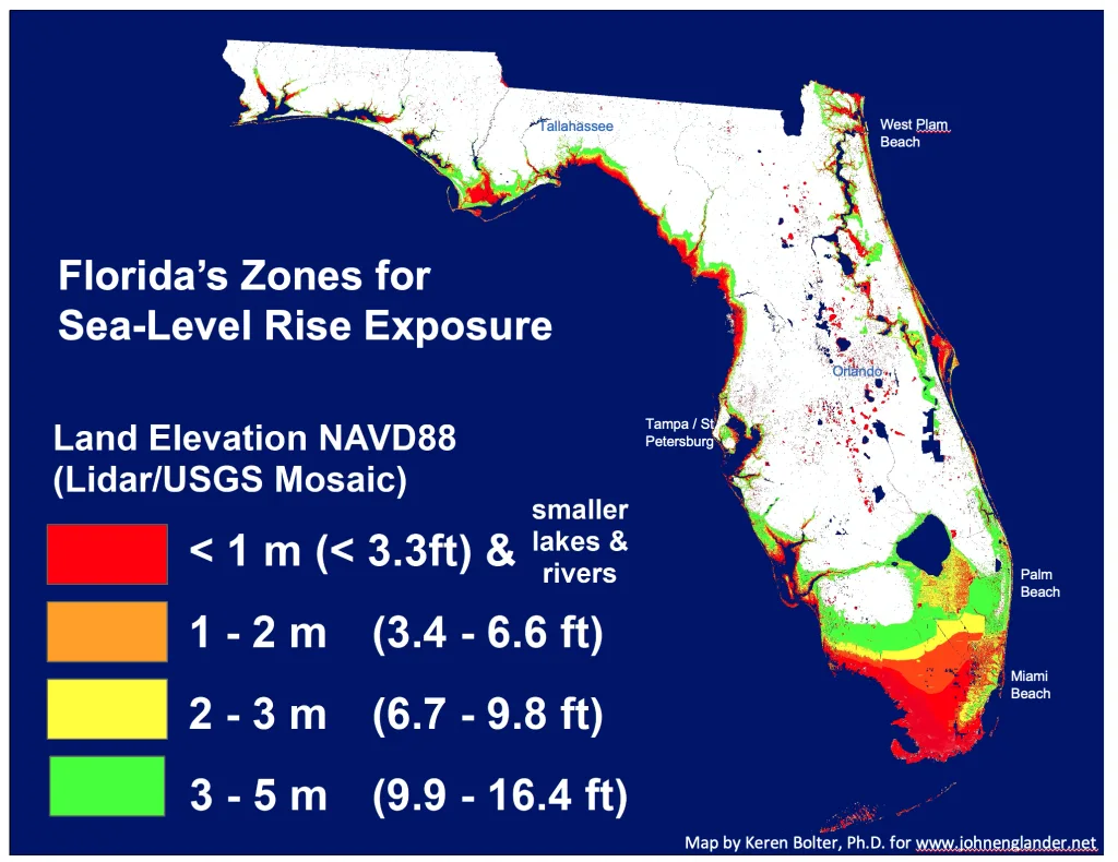
Florida’s landmass is as important as its coastline. A large portion of the peninsula sits on highly permeable limestone. When sea levels and tides rise, saltwater can pass through this rock and reach freshwater aquifers and stormwater channels. Even when the sky is clear, water can emerge from underground, reducing the effectiveness of traditional barriers and requiring attention to foundations, infrastructure elevations, and backflow controls.

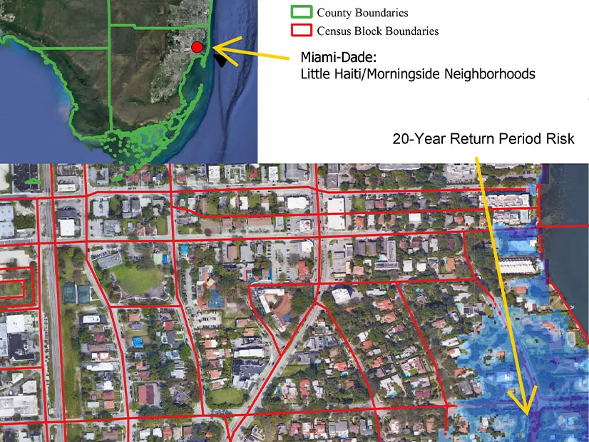
It increases the risk of exposure. South Florida is flat and low-lying, and the coastal strip is heavily developed. Since 2000, high tidal flood days have increased sharply along the Southeast and Gulf coasts, and periodic street closures have become a recurring operational problem for homes, businesses, and emergency services. These trends are well observable, seasonal, and predictable enough to be considered a design parameter rather than an exception.
Local examples are instructive. During seasonal high tides, Miami neighborhoods regularly report annoying flash floods gushing from drains and pooling in low spots. This phenomenon is not storm-related, which explains why standalone hurricane gates or higher curbs alone cannot solve this problem.
Climate Change and Sea Level Rise
Rising sea levels are a background factor that exacerbates every coastal flood. Scientific data clearly shows that the global average sea level has risen rapidly in recent years and will continue to rise throughout this century. Unless significant cuts are made in emissions, major increases will occur by the end of the century, changing the frequency of floods in many coastal areas. For designers, this means that today’s 100-year flood levels could become mid-century events, and disruptive floods could become monthly or even weekly occurrences.
Short-term forecasts help translate global scientific data into local planning windows. NOAA’s annual high tide flood forecasts now provide expected flood day ranges for regions over the coming year and show that a decade of sea level rise will expose many regions to dozens of flood days by mid-century. This shifts the approach from one-off hardening to the phased adaptation of regions and networks.
Public tools support region-specific information. NOAA’s Sea Level Rise Visualizer enables communities to visualize how rising sea levels are changing flood depths, connections, and wetland migration. These data layers can be paired with local topographic studies, drainage models, and social vulnerability indices to guide investments that protect both places and people.
Types of Floods: Storm Surge, Rainfall, Tidal
A storm surge is an abnormal rise in water level caused by wind and pressure during a storm. When the wave aligns with the astronomical tide, the combined water level is called a storm tide and can be several meters higher than normal, illustrating the destructive power of coastal cyclones.
Rain-induced flooding, commonly referred to as flash flooding, occurs when heavy rainfall exceeds the capacity of streets, inlets, and pipes. It can occur away from rivers and is common in paved areas where infiltration is limited. Since FEMA river maps do not fully reflect storm flood hazards, the absence of risk shown on the map does not mean that the area is safe from surface water.
Tidal flooding or storm surge occurs during very high tides, including large tides, without a storm. As relative sea levels rise, thresholds are crossed more frequently, and events that were once rare become routine. The cumulative effect damages roads, foundations, and infrastructure, complicating daily life in coastal areas. The compound flood, where waves, rain, and tides interact, increases depth and duration beyond what any single mechanism could produce alone.
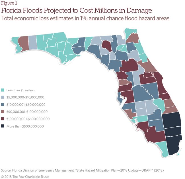
The Economic and Social Impacts of Recurring Flood Disasters
Costs are high and continue to rise. NOAA’s calculations on billion-dollar disasters in the US show a steady increase in both frequency and total losses. Tropical cyclones lead all disasters in terms of cumulative damage and average event cost. These figures directly translate into higher public spending on repairs, business interruptions, and insurance losses, which ripple through local economies.
New analyses show that we routinely underestimate the effects of flooding. The US Joint Economic Committee estimates that the cost of flooding ranges from $180 billion to $496 billion annually in 2023 dollars. This figure is equivalent to approximately 1 to 2 percent of the national GDP. This range includes direct damage, lost production, and health impacts, emphasizing that resilient design is not a luxury but a cost-saving strategy.
Uninsured losses further exacerbate the problem for households. Following recent events in Florida, modeling conducted by the First Street Foundation showed that a large portion of flood damage occurred outside FEMA’s special flood hazard areas and was likely uninsured. Recurring flood disasters also lead to daily costs rarely seen in disaster calculations, such as business closures, overtime for maintenance crews, and rapid deterioration of roads and underground systems.

Flood-Resistant Design Principles
Flood resistance is a design approach that assumes water will come, move, and recede on its own. The goal is not to prevent this inevitability in all cases, but to shape buildings to be stable, dry where necessary, resilient where possible, and capable of being repaired quickly after an event. In the United States, the primary references are FEMA’s Coastal Construction Manual and the American Society of Civil Engineers’ ASCE 24 standard. These two documents specify how foundations, exteriors, infrastructure, and cladding should be constructed in flood-prone areas.
A robust strategy is layered. Elevate the structure above design flood levels, leave the space below open for water to pass through, select water-resistant materials for areas likely to be exposed, and decide where to seal and where to allow water to enter to balance loads. These decisions are guided by NFIP Technical Bulletins, which outline code expectations for openings, materials, unobstructed areas, and breakaway elements based on flood type and site context.
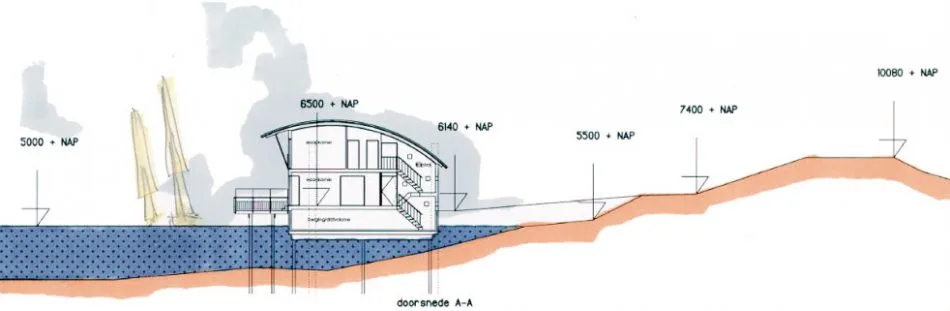
Elevated Foundations and Pedestal Structures
Open foundations shift the load from walls to piles. In Coastal Zones A and V, elevating the lowest floor on piles or columns raises living spaces above expected water levels while allowing waves and tides to pass through. FEMA’s Coastal Construction Handbook provides detailed information on foundation selection, pile driving, and load paths, ensuring that uplift and lateral forces are transferred cleanly to the ground. The principle is simple: elevate the house, minimize contact, and design it to ensure connections remain secure when water and debris forcefully impact.

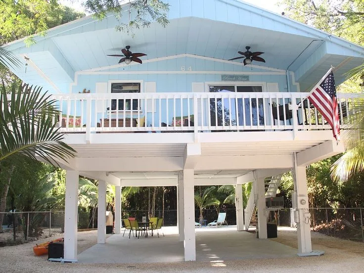
What lies beneath the elevated ground is just as important as what lies above it. According to the NFIP guidelines, areas beneath elevated buildings in high-risk coastal zones should be unobstructed or enclosed by breakable walls that can be separated from the structure without detaching it from its supports. Parking and storage are permitted, but any enclosure must not impede water flow. This reduces the load on the foundations and limits damage in the event of wave impact.
The application validates this value. After Hurricane Sandy, thousands of homes in New York were elevated or rebuilt according to new flood elevation standards by combining simplified, transitional infrastructure with higher finished floors. The same logic guides the FORTIFIED program manual. This manual ensures that homes remain on their foundations when debris and water interact by combining elevation with secure connections.
Use of Flood-Resistant Materials
Flood-resistant materials are defined as products that can withstand significant damage when exposed to direct and prolonged contact with floodwaters. This period is typically at least 72 hours. FEMA’s updated Technical Bulletin 2 lists building and cladding materials suitable for use below the base flood level and specifies that fasteners and connectors must also be resistant to corrosion and deterioration when wet. Designers should incorporate durable substrates, washable coatings, and details that can be cleaned and reused rather than discarded.
The 2025 update transitions from the old five-class rating system to clear ratings regarding acceptability, consistent with current I-Codes and ASCE 24. The document shows typical installations for Zone A and Zone V conditions and warns that some unrated products, even if they can withstand initial wetting, may damage adjacent materials. In practice, this means preferring concrete, masonry, pressure-treated framing, closed-cell insulation, and water-resistant sheathing at the required height, while keeping moisture-sensitive components at that height.
When the following height palette is honest about exposure, recovery occurs more quickly in the real world. Post-event investigations consistently show that plasterboard, MDF, and chipboard deteriorate rapidly, while concrete slabs, tiles laid on cement-based substrates, and corrosion-resistant metals can be cleaned and reused. This material realism is the cornerstone of resilient detailing.
Dry Flood Protection and Wet Flood Protection Techniques
Dry flood prevention aims to make a building waterproof up to a certain height using barriers, membranes, backflow protection, and leak-proof penetrations. According to NFIP rules and ASCE 24, dry flood prevention is permitted for non-residential buildings in A zones, but it is not permitted in V zones and is generally not permitted for residential buildings that need to be elevated. This approach requires careful design of walls and floors for hydrostatic and uplift loads, use of certified components, and planning for use and strength during an event.
Flood prevention involves intentionally allowing certain areas to fill with water to equalize pressure, thereby reducing the risk of structural failure. NFIP Technical Bulletin 7 explains how and where this is appropriate and combines it with the requirements of Technical Bulletin 1 for flood openings that relieve hydrostatic loads. Wet flood prevention, used for underground enclosures, accessory areas, or limited-use areas, is generally less complex and more reliable during extended outages because it is not dependent on pumps or active barriers.
Depth and warning time are important. FEMA and state guidelines indicate that most flood prevention methods are suitable in areas where depths are relatively shallow and that sufficient time is required to install any system requiring human intervention. In practice, many mixed-use buildings combine elevated critical systems with deployable barriers at entrances, while single-family coastal homes rely on elevation and wet flood prevention infrastructure rather than dry systems that could overload walls in the event of flooding.
Design for Water Flow and Drainage
A good flood design allows water to flow. Under tall buildings, unobstructed pathways and removable walls keep routes open to prevent unnecessary increases in velocity and impact loads caused by enclosed spaces. In A-zone areas with solid wall foundations, flood openings of appropriate size and location are required to balance hydrostatic pressure. These measures together reduce structural demand and shorten recovery time.

At the field level, transport and backflow control limits damage and disruptive flooding. Many coastal cities are upgrading discharges with one-way tidal valves to prevent high tides from pushing water back into streets and raising critical road sections to ensure access during seasonal surges. The same concepts apply to private parcels through graded terrestrial flow paths, garden ditches, permeable surfaces, and backflow valves in service connections, all coordinated to ensure a clear path for water to enter and exit the site.
Drainage design must take complex conditions into account. During tropical events, waves can occur simultaneously with heavy rainfall that overloads inlets. Therefore, FEMA’s coastal guide addresses elevation, open foundations, and materials as a package that continues to function even when pipes reach capacity and water is temporarily stored on the surface. This integrated approach ensures that neighborhoods can be reopened quickly, even when networks are under pressure.
Case Studies: Innovative Projects in Flood-Prone Areas
Designers no longer question whether the water will come. The real question is how regions can live with water and how they can quickly recover after each event. The following projects showcase different strategies that go beyond individual defense measures: from houses that rise with the floodwaters to city districts that store, divert, or temporarily contain water.
Floating Houses and Amphibious Architecture
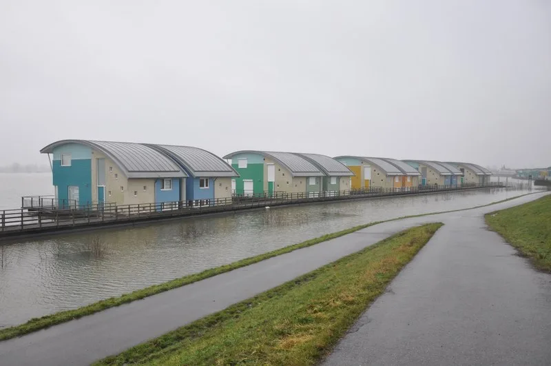
Floating and amphibious homes in the Netherlands demonstrate how daily life can adapt to seasonal water levels. In Maasbommel, 32 amphibious and 14 floating homes are located in an area along the riverbank outside the main floodplain. Each amphibious home rests on a cradle when water levels are low, rises along guide posts when the river floods, and its plumbing flexibly moves to accommodate vertical motion. During the high water event of 2011, all 46 units floated as designed and safely settled back into place when the water level dropped, demonstrating an alternative building-scale solution to continuous shoreline defenses.
Amsterdam’s new water neighborhoods take this concept from individual plots to the community level. Schoonschip is a neighborhood of 46 homes built on 30 floating plots, constructed from circular materials, equipped with a microgrid for energy sharing and on-site water systems, and led by its residents. The neighborhood is connected by piers instead of streets, and thanks to its floating foundations, the homes can rise without losing service during extreme water levels. This approach treats water not just as a hazard but as a public space, while also reducing operational emissions through distributed renewable energy sources.
Floating Office Rotterdam adds a public and commercial dimension to this typology. The wooden building, constructed for the Global Center on Adaptation, is located on a concrete pontoon in Rijnhaven and is designed to remain afloat regardless of changes in water levels. The modular structure, passive shading, and on-site energy systems transform this complex into a testing ground for climate adaptation and circularity in working environments.
Amphibious renovation projects in North America demonstrate how existing homes can be floated without permanent elevation. The Buoyant Foundation Project developed a simple system of buoyant blocks, vertical guide posts, and a subframe system that allows homes to remain on the ground under normal conditions and only rise during floods. This system offers a preservation-focused option for places like the Louisiana coast, where raising historic structures could compromise the character of the neighborhood.
Post-Hurricane Reconstruction Efforts in Florida and Louisiana
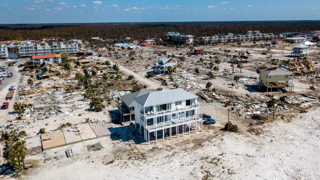
After Hurricane Michael in 2018, the “Sand Palace” in Mexico Beach, Florida, became a visible testament to the concept. Built on a high platform with reinforced connections and insulated concrete forms, this structure withstood the storm’s waves and winds while many neighboring buildings collapsed. This house was not lucky. Designed for extreme loads, with fewer points of failure and a robust exterior performance, this structure demonstrates how code-plus strategies can change outcomes.

The recent hurricanes that hit Florida served as a large-scale field test for building standards. Research conducted by the Insurance Institute for Business and Home Safety (IBHS) following Hurricane Ian revealed that modern, well-implemented regulations reduced structural losses and that certain roof systems, such as properly installed metal, performed better than commonly used asphalt shingles. These findings continue to inform updates to Florida regulations and the IBHS FORTIFIED guidelines, and many homeowners now choose to go beyond the basic requirements.
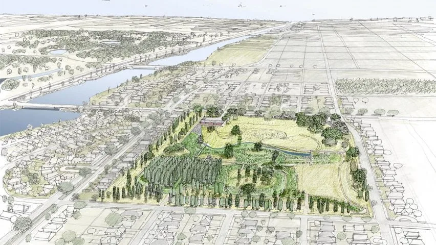
Louisiana’s approach combines home-based measures with watershed-scale planning. New Orleans’ Gentilly Resilience District and Mirabeau Water Garden transform urban land into storage, infiltration, and education areas, reducing street flooding and subsidence issues in vulnerable neighborhoods. Along the coast, the state’s 2023 Coastal Master Plan establishes a long-term, science-based risk reduction and land development program, even as individual components evolve. These efforts demonstrate how structural works, green infrastructure, and community programs reinforce each other.
Urban Projects in Miami, New Orleans, and Houston
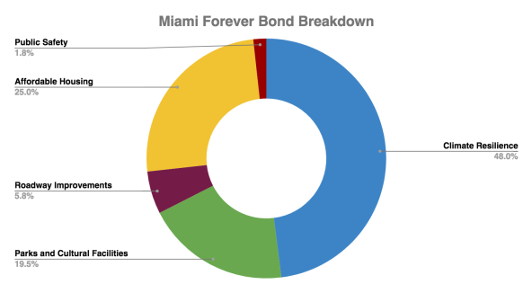
Miami is combining capital programs with new standards to create a place where daily tides and heavy rains can flow. Miami’s 2024 Stormwater Master Plan establishes a citywide plan for pumps, discharges, and storage, while the Miami Forever Bond allocates hundreds of millions of dollars to reduce sea level rise and prevent flooding. Miami Beach complements this with tide valves, pump stations, and select road elevation projects to keep access routes dry during seasonal surges. These investments incorporate flood control into routine street and infrastructure work.

New Orleans has turned water from enemy to neighbor. The Gentilly Resilience District, which includes the 25-acre Mirabeau Water Garden, consists of a series of projects that store and slow rainwater in low-lying areas between historic canals and swamps. The city’s resilience documents describe the shift from rapid drainage to controlled retention. Parks and campuses are being used as flood prevention assets that cool neighborhoods and add value every day.

Houston expanded its bayou-based strategies. Buffalo Bayou Park was designed for flooding and rapid recovery, proving that public open spaces can also be used for transportation and storage during extreme storms. Across the region, Bayou Greenways 2020 created continuous green corridors connecting parks while also providing space for high water levels. At the project level, long-term initiatives like Project Brays are widening channels, renovating bridges, and adding billions of gallons of storage capacity. The U.S. Army Corps of Engineers’ Buffalo Bayou and Tributaries study is evaluating deep tunnel alternatives.
International Lessons: The Netherlands, Bangladesh, and Beyond
The Netherlands approaches the adaptation process as a national spatial policy. The Room for the River project has created areas where the highest flows can occur by transitioning from higher dikes to wider rivers, relocating dikes, cutting side channels, and lowering floodplains in over 30 projects. The ongoing Delta Program coordinates water safety, freshwater, and climate-resilient planning through annual updates of its priorities, aiming to achieve these goals by 2050. The lesson to be learned is simple: design a landscape that can withstand the threat, then build structures and areas that are compatible with it.

Bangladesh’s Delta Plan 2100 is a long-term, cross-sectoral strategy that links flood risk, navigation, agriculture, and development goals. Alongside national efforts, grassroots innovations such as Shidhulai Swanirvar Sangstha’s solar-powered floating schools transform waterways into social infrastructure networks by providing education and services to communities isolated by monsoon waters. Together, they demonstrate how grand plans and local ingenuity come together on the same water.
Other coastal regions are trying to strike a balance between protection and flexibility. Venice uses MOSE gates to prevent extreme Adriatic waves from flooding the city and implements a movable barrier system on an urban scale. In contrast, Dutch cities such as Rotterdam are developing tidal parks and water-sensitive public spaces that accept daily dynamics while improving ecology. These approaches are different tools within the same kit, selected according to context, culture, and risks.
Technological Tools and Materials That Increase Durability
Design teams are increasingly combining technologies that ensure proper positioning and structures, keep water visible, manage it on the surface, and keep it away from areas that must remain dry. Below are tools and materials that support durable applications, along with the best places for them to work and important considerations.
Smart Sensors and Real-Time Monitoring Systems
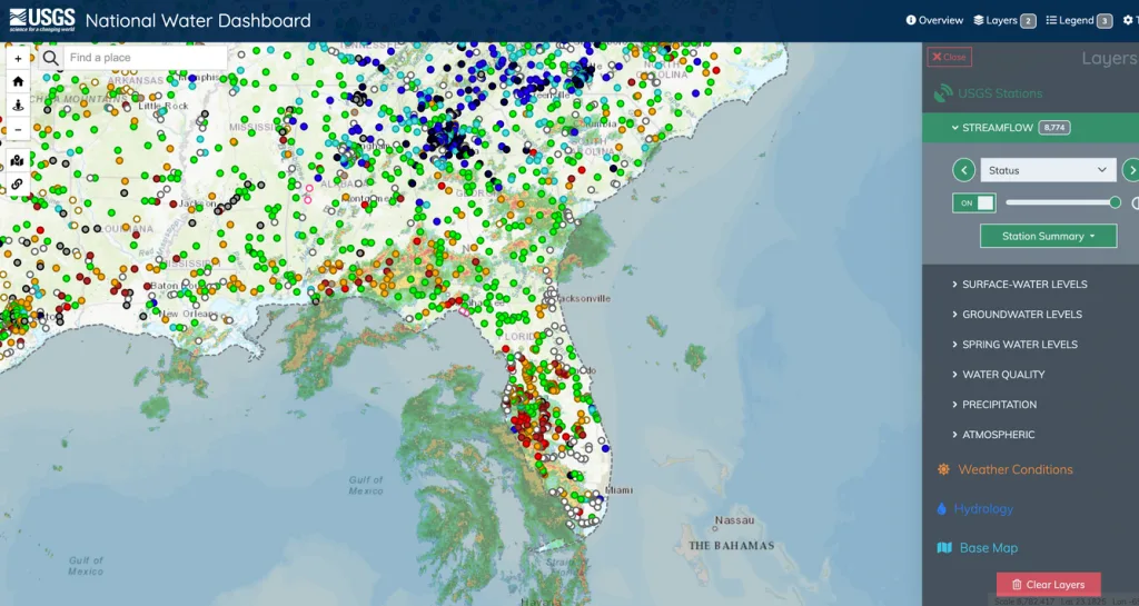
What do they do and why is it important? Reliable, high-frequency water data enables stakeholders to transition from static maps to live risk imagery. Along the U.S. coastline, NOAA’s water level stations update every six minutes and feed tide, wave, and coastal flood products used by ports and cities. At the river scale, the USGS National Water Indicator Panel aggregates thousands of measurement devices and connects to WaterAlert, so field teams receive text messages or emails when levels exceed defined thresholds. These systems turn rising water levels into actionable lead time.

From observation to prediction. Observations only tell half the story. NOAA’s National Water Model provides continuous, continent-wide flow guidance and peak flood level predictions for the next few days. This helps coordinate pump stages, road closures, and construction halts across portfolios. Coastal operators combine this with PORTS, NOAA’s real-time network for water levels, currents, winds, and bridge clearance heights in major ports.
How do designers use this? Project boards typically combine local NOAA or USGS stations with site cameras and rain gauges. Teams set warning thresholds linked to temporary barriers or elevator lockouts, then document the protocol in the operations plan so actions are automatically triggered during an event.
Innovations in Waterproofing and Permeable Surfaces
Self-sealing underground membranes. Bentonite geosynthetic clay liners have become standard for blind side and positive side foundation work in wet soils. When hydrated, the clay swells, closes small holes, and forms a barrier with very low permeability. Public specifications from the US Department of Defense and major manufacturers describe their installation in walls, slabs, pits, and contaminated areas. The key considerations here are protection against early wetting and proper mechanical anchoring.
Crack-resistant concrete chemistry. Crystalline admixtures and other self-healing materials reduce water permeability and increase durability in areas where intermittent wetting is expected by sealing micro-cracks over time. Recent studies report significant reductions in permeability and increases in durability, while also noting that performance varies depending on mix design and exposure conditions. Specify based on testing and verification, and maintain moisture-affected surfaces at the required height according to FEMA guidelines for flood-resistant materials.
Let the soil do its job. Permeable pavements made of permeable asphalt, permeable concrete, or permeable interlocking pavers allow rainwater to seep into the storage layer and underlying soil, reducing peak flow and filtering pollutants. EPA and FHWA technical summaries outline the site selection, structural design, and maintenance required to keep voids open and performance high. Use these systems to drain front yards and parking lots during normal storms and plan safe overflow routes for extreme events.
GIS and Flood Modeling for Field Planning
Start with the right layers. FEMA’s National Flood Hazard Layer and Map Service Center provide effective FIRM data and web services that connect directly to GIS for rights and code checks. For coastal scanning, NOAA’s Sea Level Rise Visualizer shows how sea level rise changes depth, connectivity, and frequency with confidence layers. The USGS 3D Elevation Program’s high-resolution LiDAR provides the terrain information needed to assess flow paths, design berms, and determine safe access routes.
Model hydraulics and drainage. For rivers, surface runoff, and combined sewer overflows, HEC-RAS 2D maps depths and velocities in the project network and connects directly to GIS terrain. For field drainage and road transportation, EPA’s SWMM simulates rainfall, storage, pipes, and control structures, allowing teams to determine the dimensions of permeable surfaces, inlets, and retention areas while testing for blockages and extreme events. Together, they convert maps into design sections and operational rules.
Incorporate forecasts into your decisions. During construction and early operation phases, combine National Water Model flow guidance with local measurement devices to determine the timing of casting, material delivery, and flood prevention applications. Document these triggers in the field emergency action plan and review them each season.
Modular and Prefabricated Flood-Resistant Units
Lightweight, elevated, and portable. In floodplains where water rises rapidly, modular units that can be quickly assembled, elevated on lightweight foundations, and even moved seasonally offer a practical solution. In Bangladesh, Marina Tabassum’s Khudi Bari project uses a simple two-story bamboo and steel space frame to provide daily living on the lower level and shelter on the upper level, and can be dismantled and transported by a small team. The project’s recent recognition highlights the value of low-cost, mobile resilience.
Factory-built homes compliant with flood standards. In U.S. recovery programs, prefabricated and modular homes must meet elevation and foundation requirements when placed in mapped flood hazard areas. FEMA’s guidance and HUD’s adoption of the Federal Flood Risk Management Standard strengthen the free board above the local flood level for financed housing, making elevation a foundation rather than a lift.
Rapid prototypes and regional programs. After Katrina, universities and public studios along the Gulf Coast continued to develop prototypes for viable, code-compliant homes and neighborhood strategies. LSU’s Coastal Sustainability Studio is a long-standing center for applied research and reconstruction. These efforts combine modular delivery with local planning, ensuring that units are not only quickly assembled but also form part of a region-scale water strategy.
Policy, Planning, and Community Participation
A good flood policy harmonizes money and people. Regulations and zoning plans reduce pre-storm exposure risk. Insurance and grants transform recovery efforts from temporary aid into planned investment. Community processes ensure that measures are applicable in real neighborhoods and real buildings, then translate these choices into long-term plans that shape streets, parks, public services, and housing.
Updated Building Regulations and Zoning Regulations
Raise basic standards with contemporary codes. The most effective resilience measure is the adoption and implementation of modern disaster-resistant codes. FEMA’s Building Code Adoption Tracking shows the percentage of communities adopting the latest I-Codes in each region, as new versions include references to ASCE 24 for stronger flood measures and flood-resistant design. Consider code currency as a project due diligence element and municipal KPI.
Use ASCE 24 with the 2024 I-Codes. ASCE/SEI 24-24 establishes minimum requirements for foundations, infrastructure, and materials in flood-prone areas and is referenced by the 2024 International Codes. FEMA’s accompanying summary outlines how the 2024 I-Codes address topics such as flood openings, the lowest structural elements in Coastal Zone A, and enclosures. Design teams should confirm which version applies locally and where free-board or coastal provisions exceed the minimums.
Update the zoning plan for the floodplain. The zoning plan can eliminate conflicts for resilient projects by providing height and envelope flexibility to meet height and access requirements, limiting sensitive uses, and allowing for partial renovations. New York City’s Coastal Flood Resilience Zoning Plan achieves this citywide, allowing buildings to be elevated and retrofitted while preserving neighborhood character, and is the result of a multi-year public process. Consider this a model for overlapping areas in coastal cities.
Insurance, Incentives, and Financing Programs
Price risks correctly, then reduce the reward. FEMA’s Risk Rating 2.0 system modernizes NFIP pricing to reflect a broader set of risk variables, while the Community Rating System (CRS) offers community-wide premium discounts of 5% to 45% when local governments exceed minimum floodplain standards. Together, pricing and CRS credits create a long-term incentive to raise and maintain standards.
Take advantage of federal disaster prevention funds. FEMA’s Disaster Prevention Grant Program provides post-disaster funding for plans and projects that reduce future losses. Flood Prevention Assistance funds upgrades, purchases, and other projects that specifically reduce claims on NFIP-insured buildings and is implemented through selections published annually. These grants convert recurring losses into targeted improvements and, when combined with CRS activities, can reduce premiums across the community.
Learn about the current status of BRIC and its alternatives. FEMA’s BRIC program has historically funded proactive infrastructure and code adoption efforts. In 2025, the program’s cancellation and subsequent lawsuits created uncertainty about future BRIC awards. Therefore, property owners should monitor FEMA notifications and be prepared to transition to HMGP, FMA, and state funds if possible. Florida’s Resilient Florida grants and My Safe Florida Home program demonstrate how state programs can supplement federal funds, but federal funds focus on wind rather than flood.
Use insurance to finance compliance. NFIP policyholders can take advantage of Increased Compliance Costs insurance for up to $30,000 to cover the costs of upgrading, relocating, demolishing, or non-residential flood prevention work when a building is significantly or repeatedly damaged. Combine ICC with local permits and expand its scope for resilient, code-compliant solutions.
Community-Led Resilience Initiatives
Work with neighborhood residents to develop neighborhood-scale plans. New York City’s Resilient Neighborhoods program identifies block-level strategies—from raising small homes to reprogramming ground floors—and the necessary zoning changes to make them feasible. Brochures and neighborhood plans show how local workshops and field trips translate into mapped actions the city can adopt. Consider this a replicable participation format for coastal councils.
Turn rainwater projects into public spaces. New Orleans’ Gentilly Resilience District and Mirabeau Water Garden projects combine storage and infiltration features with education and open spaces, supported by social assistance personnel and publicly available information forms. In Houston, Bayou Greenways demonstrates that green corridors can store water, connect parks, and attract investment through public-private partnerships. These examples show that flood prevention efforts also improve residents’ daily lives.
Make shared benefits visible to build support. Public communication that quantitatively expresses heat relief, mobility, property value stability, and insurance savings helps communities maintain momentum. Houston’s bond history and Greenways reports clearly show who is funding what and why, serving as a template for other regions seeking lasting support.
Integrating Flood Resilience into Urban Master Plans
Integrating water into public spaces. Rotterdam’s adaptation strategy uses multi-layered protection and water-retaining public spaces. Benthemplein Water Square is both a square and a water retention basin, and is partially financed by water authorities. This logic scales from one block to entire neighborhoods, transforming rainfall events into manageable, reversible land use.
Don’t plan isolated projects; plan blue-green networks. Singapore’s ABC Waters Program transforms canals and reservoirs into interconnected parks that improve water quality and livability. The program offers a portfolio of completed projects and design guidelines. These networks function as infrastructure and daily living amenities, thereby aligning capital programs with public support.
Align capital, codes, and community input. Miami’s Sea Level Rise and Climate Readiness strategies and the Miami Forever Bond demonstrate how bonds, master plans, and alignment areas can be used to finance road elevations, tide valves, and park renovations in coordination with a city’s zoning and building standards. Master plans should bring together funding sources and implementation tools to advance a clear and publicly accessible series of projects within each annual budget.