
The Idea of Urban Calendars
Cities do not merely occupy space; they also organize time. Long before mechanical clocks standardized hours, urban settlement patterns were used as a tool to track seasonal changes, ritual cycles, and agricultural tasks. In the Maya plains, the E-Group complexes, with their elevated western platforms featuring a triple alignment facing east, encoded repeatable sunrise alignments linked to agriculturally significant dates, transforming the plazas into working calendars that determined planting, harvesting, and ceremonial schedules.


The same impulse emerges at different scales and periods. Teotihuacan’s grid, deviating from the north, supports the alignments recorded in important monuments; this is evidence that the city’s plan synchronized civil life with solar events throughout the year. In other words, the street network itself functions as a temporal tool, placing processions and ceremonies within a cosmological program.
Modern cities still showcase this intertwining of time and form in magnificent ways. Twice a year, the “Manhattanhenge” phenomenon, when the setting sun aligns perfectly along Manhattan’s east-west avenues, serves as a reminder that even a 19th-century grid can create urban temporal effects when the sun and street directions coincide, rather than being merely a party trick. This phenomenon dramatically illustrates how the plan’s orientation can script shared moments across the city, even long after its authors have disappeared.
Why Should Architects Pay Attention?
Design always regulates the rhythms of bodies, light, temperature, traffic, and commerce. Today, we know that exposure to daylight and appropriately adjusted electric light supports circadian health, cognitive function, and sleep. Performance standards such as the WELL Building Standard formalize this relationship by setting daytime “equivalent melanopic lux” targets. Therefore, temporal thinking becomes as much a health strategy as it is an aesthetic strategy.
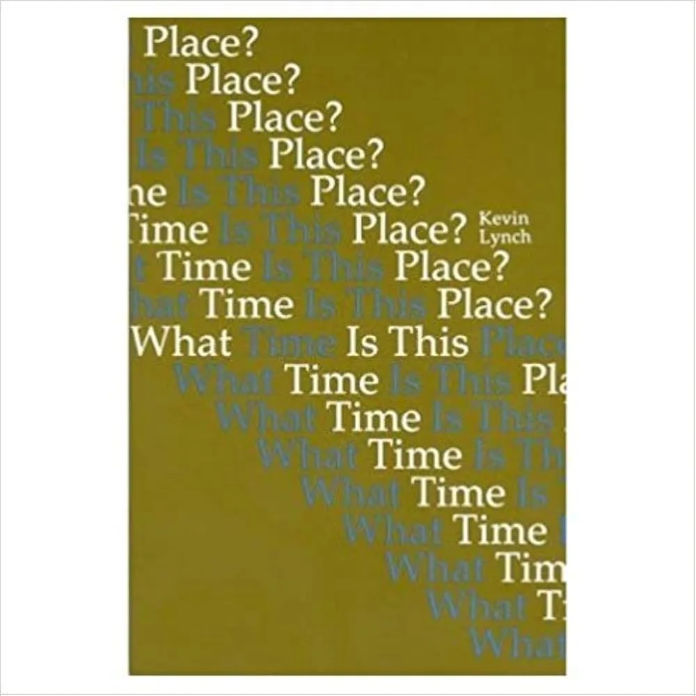
Urban planners have also argued that spaces have their own unique temporal signatures—meaning they follow daily, weekly, and seasonal patterns—and that instead of fighting against these patterns, designs can be created that align with them. Kevin Lynch’s classic work “What Time Is This Place?” redefined the city as an environment that records, stages, and organizes temporal processes, while subsequent “rhythm analysis” studies have shown how social rhythms and built forms influence each other. For practitioners, this means that street sections, facades, and programs must be tested according to cycles.

Temporal thinking also sharpens policy. Standardized time emerged to solve very concrete urban-regional problems: Railways needed synchronized clocks to operate safely and on time, which incorporated cities into national time regimes. When you coordinate stations, shops, and services according to a common clock, you are literally planning a city in time.
Temporal Infrastructure in Ancient and Modern Contexts
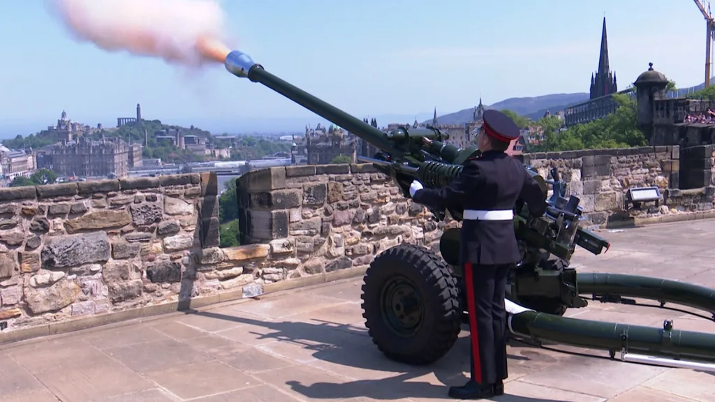
Before radio signals emerged, ports and capitals relied on visual and auditory time signals placed on the horizon. Greenwich’s red Time Ball continues to drop precisely at 1:00 PM every day. This device, used in the 19th century to help ships set their chronometers, became a public ritual. In Edinburgh, the One O’Clock Gun booms loudly across the city to help sailors in Leith set their clocks. This daily performance has merged military equipment with civilian time measurement and, consequently, urban routine.

These are not strange curiosities. They show that cities build equipment for time: stone towers, signals, bells, and calendars. The origins of this tradition stretch back to New Year’s Eve in Times Square, essentially a modernized ball drop, and further back to ancient alignments that transformed boulevards and pyramids into seasonal markers. A city’s “temporal infrastructure” is as real as its pipes and cables; it regulates coordination, memory, and shared expectations.
How Cultural Rhythms Influence Urban Form
Culture sets the pace. During Ramadan, commercial life in many cities shifts decisively to late night hours; transaction data shows that spending increases between 10:00 PM and 4:00 AM, and this has implications for public transportation schedules, lighting, staffing, and public space management. Designs expecting a “normal” daily intensity fail here; designs that follow the month-long nighttime rhythm may succeed.
The Hajj further reinforces this principle. The urban fabric of Mecca has been reshaped due to periodic population surges during the Hajj. This situation has led to the redesign of bridges, circulation routes, and multi-level platforms around ritual areas based on crowd science. Urban management and architecture demonstrate how time-bound rituals can leave lasting spatial traces by responding to events on the calendar with predictive analyses and purpose-built structures.
Even outside of sacred cycles, daily markets, nightlife, and work weeks inscribe repeating rhythms onto streets and halls. Research on “urban rhythms” shows that the same square is perceived differently depending on the time of day and day of the week, and that weekly or seasonal rhythms (Sundays, summer evenings, festival weeks) can serve as catalysts for flexible design rather than competition. When architects align form and program with these rhythms, they create spaces that feel “timely” for their communities.
Teotihuacan: Aligning the Avenue of the Dead
The Sun and Celestial Axis in Mesoamerican Planning
The Avenue of the Dead, which forms Teotihuacan’s north-south axis, does not precisely mark true north. This avenue lies approximately 15.5 degrees east of north, and the rest of the city is oriented accordingly. Archaeologists have shown that the plan actually contains two closely related “families” of alignments, oriented approximately 15.5° and 16.5° clockwise from the cardinal directions. These orientations appear to have been deliberately chosen based on the sun’s local sunrise and sunset throughout the year, rather than being the result of a measurement error. In short, the street grid also serves as a clock.
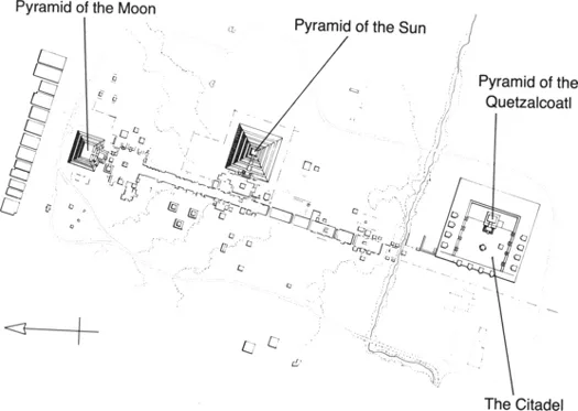

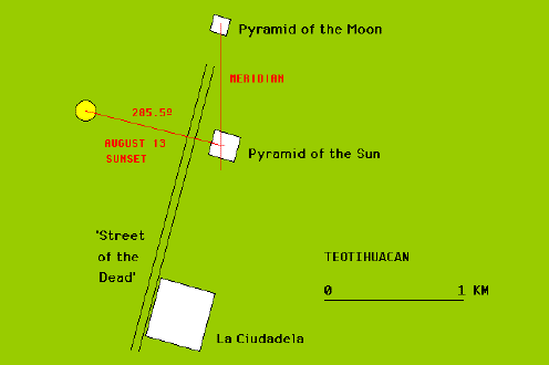
The best evidence lies in the large monuments fixed to this grid. Measurements of the east-west axis of the Sun Pyramid show that, for an observer at ground level, this line captures sunrises around February 11 and October 29 and sunsets around April 30 and August 13. These dates are not random; they recur at useful intervals for tracking the seasons. The same study suggests that the other alignment families expressed at the Citadel and the Temple of the Feathered Serpent function as an observation scheme matched to these dates. Together, they form a practical solar calendar encoded into the architecture.
Ritual Synchronization and Festival Dates
When you place these dates within the Mesoamerican ritual rhythm, an elegant pattern emerges. The sunset pair of the Sun Pyramid, from April 30 to August 13, when read with its complementary signs, covers a period of 260 days. This period corresponds to the full length of the sacred calendar used in the region, the tonalpohualli. Scientists argue that the sunrise orientations of the Ciudadela are positioned in twenty-day increments between these two dates, creating easily usable intervals for planning ceremonies, markets, and agricultural work in conjunction with the arrival of rains, the ripening of corn, and the turning of the ritual year. These alignments do not tell us the names of the ceremonies, but they reveal a city plan designed to mark them on repeatable, observable days.
These signs were not limited to abstract azimuths. Urban performance was concrete and collective: processions advanced along a gently sloping avenue, reaching squares and platforms where the crowd could see the timing of the sky. The terrain itself participated in this process: the northern tip of the Moon Pyramid rose toward the silhouette of Cerro Gordo, providing a fixed horizon target and a theatrical destination that united the procession, the ritual, and the program. In this sense, Teotihuacan choreographically arranged how bodies moved through space, synchronizing them with the calendar.
Urban Geometry as a Cosmic Mirror
Geometry reflects the landscape as much as the sky. The Moon Pyramid dominates the end of the avenue and visually “locks” onto Cerro Gordo behind it, transforming a natural peak into a cosmic backdrop and a practical sightline. Recent research frames this as a broader Teotihuacan practice: pyramids and mountains were arranged in long-distance alignments that stabilized the city’s orientation for centuries. The result is a civic compass where architecture, horizon features, and celestial events reinforce each other.
Researchers also left smaller traces. At Teotihuacan, “pecked crosses” (carefully carved stone markers) were used as reference points and accepted as part of a standard measurement system. These suggest a culture of precise planning, where astronomical directions and modular ground control worked together, and builders transformed cosmic ideas into block-by-block construction.


Contemporary Space Design Courses
Teotihuacan demonstrates how a plan can become a shared moment. Today’s designers can borrow this logic without imitating it: by aligning important sightlines or plaza edges, they can trigger spontaneous gatherings across the city by ensuring that the setting sun travels along a street axis for a few evenings each year. New York’s “Manhattanhenge” is a coincidental version of this effect, proving that when urban orientation and solar geometry align, people notice and go outside. Such deliberately planned alignments can anchor annual festivals, civic rituals, and seasonal programs to that place.


There is also a pragmatic lesson regarding redundancy. Teotihuacan did not rely on a single date or a single structure; it ensured that different periods of the year could be read from different perspectives by using dual alignments, horizon features, and sequential plazas. Today’s regions can mimic this flexibility by distributing temporal cues—such as shadow-tracking installations, sunrise corridors, and seasonal wind bows—across a walkable network. The goal is to create a structure that helps communities feel the passage of the year together, just as Teotihuacan once did.
Beijing: The Forbidden City and the Lunar Cycle
Dynastic Power and the Command of the Heavens
The imperial center of Beijing is a diagram of time and cosmic order. The name “Zijincheng,” commonly translated as “Forbidden City,” refers to the Pole Star (ziwei), the celestial throne of the supreme deity. Placing the emperor at the center of this earthly “pole” was not a mere metaphor; it was the political theology of governance. The palace’s layout, colors, numbers, and thresholds were arranged to indicate that the Son of Heaven ruled in harmony with the rhythms of Heaven.

Calendar making transformed this symbolism into daily governance. In Imperial China, publishing an accurate calendar was the duty of the sovereign: it synchronized agriculture, rituals, taxation, and court ceremonies. When Ming and early Qing rulers noticed discrepancies in their calculations, they revised them. Most famously, in the 17th century, they authorized court astronomers and Jesuit scholars to rebuild the instruments at the Beijing Old Observatory and publish the Shíxiàn (Chongzhen) calendar. Thus, the city’s ritual life and the emperor’s legitimacy became dependent on precise calculations of the moon and sun.
Cardinal Directions and Equinoxes
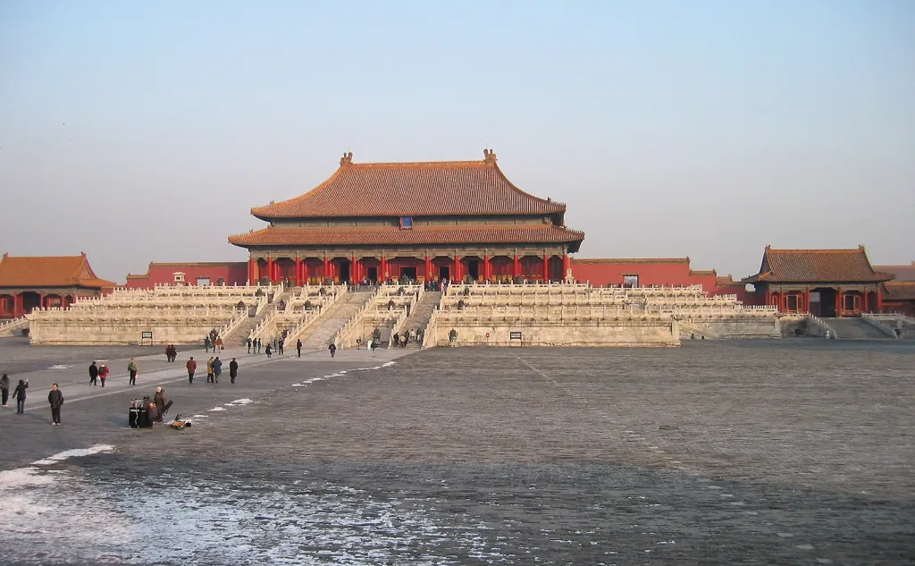
The layout of the capital city conforms to the old planning rules, which envisioned a square-shaped city oriented toward the four cardinal directions and a main ceremonial route along the north-south axis. The Forbidden City is located along this axis, stretching from Tiananmen Square to the Drum and Bell Towers. Cardinal alignment has made the city a stage where seasonal events are legible. At the equinoxes, when the sun rises exactly in the east and sets exactly in the west, the clarity of these directions becomes part of the civic experience, while the towers at the northern end of the axis have historically chimed the hours that structured urban life.
Beijing also externalized the solar and lunar cycles in special altar parks. In the east, Ritan (the Temple of the Sun) hosted the imperial spring equinox ceremonies, while in the west, Yuetan (the Temple of the Moon) held sacrificial ceremonies for the autumn equinox. These places completed the axis of the palace: the balance of the sun and the cycles of the moon were honored with sacrifices on specific dates, and the lunar-solar calendar was combined with parades, costumes, and music held at the city gates and in the streets.

Seasonal Ceremonies and Public Architecture
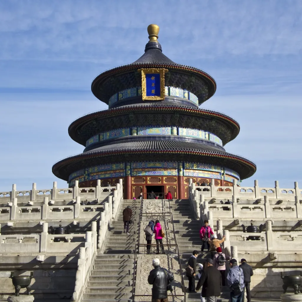
Every winter solstice, the emperor would depart from the Forbidden City and set out for the Temple of Heaven in the south. Here, the Circular Mound Altar and the Hall of Prayer for Good Harvests formed the architecture of state ceremonies. The complex was designed to embody the hierarchy between earth and sky, and the ceremony itself (fasting, camping, offerings) was timed according to the turning of the year. The spaces were read as tools: round for the sky, square for the earth; blue tiles above, white marble below; alignments, steps, and altars reinforced the city’s role as a stone calendar.
The annual cycle continued throughout the compass. In Ditan, at the Temple of Earth, the summer solstice sacrifices responded to the winter rituals at the Temple of Heaven. In spring, Ritan’s equinox ceremony was revived as a public cultural festival, showing that a ritual once reserved for the palace now belonged to the entire city. The same places that once synchronized the dynasty and the cosmos now define contemporary civil time: weekend fairs, seasonal reenactments, and nighttime events that still follow the moon.
A Lasting Impact on Chinese Urbanism
Beijing’s central axis continues to serve as the city’s planning backbone, while the Bell and Drum Towers are remembered as historical timekeepers. The idea that urban form should record time continues in softer forms: parks and waterfronts organize seasonal events, and designers increasingly reference the “Twenty-Four Solar Terms,” a traditional system recognized by UNESCO as intangible cultural heritage that organizes the year according to the sun’s position along the ecliptic. In recent landscape and new urban projects, these terms are used to shape plant palettes, lighting, and festival calendars, allowing residents to feel the passage of the year as they move through the space. The effect is both old and new: a city that still sees time as part of its architecture.


Jaipur: The Convergence of Vedic Astronomy and Urban Design
Nine-Square Mandala Grid
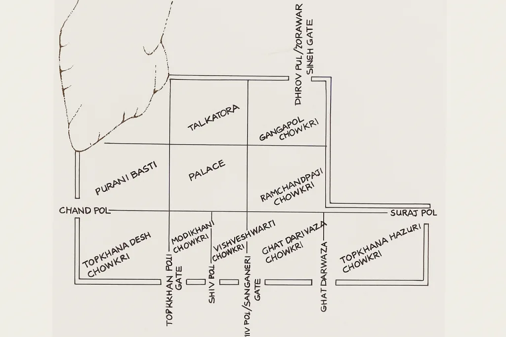
Jaipur was founded in the 1720s with a rare goal for that era: to build a capital city that reflected cosmic order in its daily streets. The city, surrounded by ancient walls, has a strict grid layout derived from the Indian planning principle Vastu Shastra, which connects the main directions, proportions, and social life. Instead of winding streets, wide, straight avenues converge in choreographed squares, markets stretch out in long, columned galleries, and gates adorn the walls. The clarity of the plan was intended to be readable as a walkable schematic.
At the center of this diagram is a famous nine-part diagram. The earliest plans show a city divided into nine large “chowkris,” interpreting the nine-square mandala that Vastu uses to harmonize human settlements with the cosmos. Popular narratives and later academic studies link the nine sectors to the Navagraha (the nine planets in Indian astronomy and astrology), placing the ruler’s palace and temple on the axial center line. Even if hills disrupt the geometry, the purpose remains visible: a mandala depicted as urban fabric.

The grid still regulates how people move, trade, and meet. The two nodes, Badi Chaupar and Chhoti Chaupar, form the center of the east-west market and serve as a breathing space for market crowds and festival processions. Their scale and location transform an abstract diagram into an urban theater, allowing the city to breathe during peak hours and ceremonial nights.
Integration of Solar Observatories
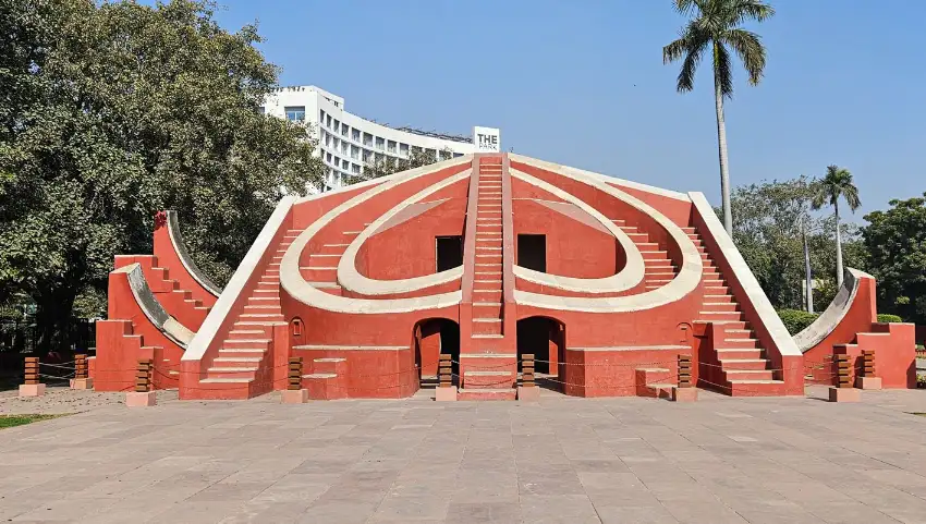
Jaipur measures the sky. A short walk from the City Palace lies the Jantar Mantar campus, home to monumental instruments made of stone and marble that track the sun, map the sky, and refine the calendar with the naked eye. The massive gnomon of the Samrat Yantra casts a shadow on a precise scale, while the Rama Yantra and the bowl-shaped Jai Prakash allow observers to step into geometry and read altitude, azimuth, and hour angles directly from the sky. These are architectural machines that make time visible for the city.

Keeping a calendar was both a practical and ceremonial task. Observations made using the Jantar Mantar were transferred to ephemerides and tables, enhancing the accuracy of the local panchang (almanac) used for planning agricultural work, determining festival dates, and selecting appropriate times for state ceremonies. A device called the Yantra Raj astrolabe was traditionally used to calculate the Hindu calendar on a specific date each year. This device served as a clear bridge between celestial mechanics and civil time.
This lesson is striking for architects: in Jaipur, scientific infrastructure is not hidden away in laboratories. It is expressed as a public space. The observatory’s terraces, staircases, and pedestals invite people to take measurements, transforming the city into a classroom where time and space are learned together.
Calendar Festivals and Social Rhythm
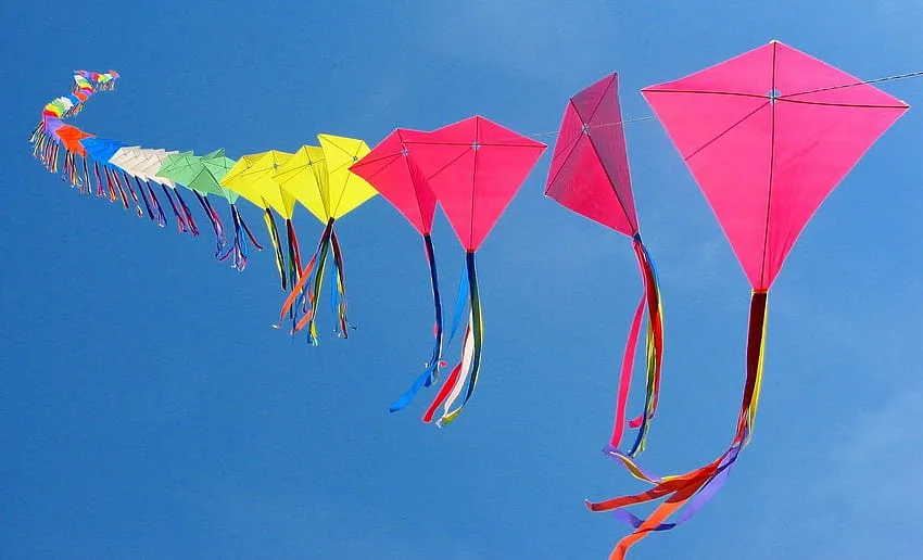
A city built to track the sun naturally fosters a calendar-like way of life. Every January, Jaipur’s sky fills with kites during the Makar Sankranti sun festival, symbolizing the sun’s transition into Capricorn and its journey northward. The date is astronomically determined, and the celebration spreads across rooftops and marketplaces, transforming the grid-like silhouette into a colorful canopy. The festival’s popularity reminds us that solar events here are not abstract, but social, tactile, and urban.

The same squares and streets also host other cycles: Sundays, parades, and seasonal fairs. Thus, the plan becomes the metronome of daily trade and ritual life. Restored chaupars host gatherings that increase and decrease throughout the year, while long markets regulate traffic like steady rhythms between crescendos. Ongoing debates today about heritage management and sales rights prove the vitality of this rhythm: when a plan functions as a temporary infrastructure, its spaces continue to be in demand.
Astrology and Spatial Hierarchy
The founder of Jaipur, Sawai Jai Singh II, was both a statesman and an astronomer. He established observatories in North India and supported the preparation of new astronomical tables. He did this not only for science, but also to enable the people to measure time more reliably through observations and to ensure that horoscope interpretations were more accurate. Astronomy and jyotish (astrology) were intertwined in court culture, and the city reflected this synthesis with its skyward-facing hierarchy: the palace and temple were aligned along an axis, gates were named and positioned for symbolic purposes, and sectors were organized according to role and rank.
This cosmological interpretation did not end in the 18th century. Modern Jaipur continues to reinterpret the idea of nine squares. The most famous example of this is Charles Correa’s work, Jawahar Kala Kendra, where each square becomes a “planet” pavilion in a contemporary cultural complex. The building makes the city’s old logic understandable again: a plan can be both a map of the heavens and a machine for daily life.
When read this way, Jaipur offers a clear proposal for creating contemporary spaces: align the settlement pattern, architecture, and public rituals with the actual cycles of people’s lives. When the grid carries meaning beyond traffic engineering, when it follows the calendar, you get streets that don’t just carry people. They carry time.
Washington, D.C.: Building a Capital City with Solstice Lines
L’Enfant’s Master Plan and Symbolic Dates
Washington’s plan began as a clear composition of axes and vistas. Pierre Charles L’Enfant placed wide diagonal avenues on a linear grid and used Pennsylvania Avenue as the ceremonial axis between the Presidential Residence and the Capitol Building, linking power to geography. He also envisioned large public spaces extending south of the White House and west of the Capitol Building—the seeds of today’s National Mall—so that the government would take center stage within long, legible sightlines rather than hiding in the streets.

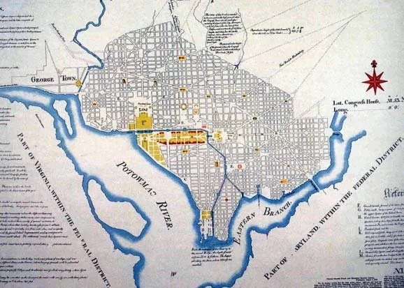
The city’s calendar was quickly carved in stone. The cornerstones became public timestamps as much as milestones in construction: the cornerstone of the White House in 1792 and, more famously, that of the U.S. Capitol Building on September 18, 1793, when George Washington presided over a Masonic ritual with corn, wine, and oil before a large crowd. These ceremonies anchored civic memory to specific dates and created anniversaries that Washingtonians still commemorate and debate.


Capital Alignments and Equinox Axes
Since the shopping center essentially extends east-west, the equinoxes transform it into a natural light theater. Around the end of March and the end of September, the sun rises in the east; the line stretching from the Capitol to the Washington Monument and the Lincoln Memorial briefly becomes a city-sized gnomon, and photographers gather here as the first light axis illuminates even the interior of Lincoln’s room. This scene is less evidence of a mysterious conspiracy and more a geometric result of the city’s east-west spine aligning with the sky’s clock.
This spine originates from L’Enfant’s “avenue” extending westward from the Capitol. A void designed to frame monuments and parades. When the sun accompanies it, it also frames time, reminding residents that this plan was drawn to organize shared moments that recur twice a year with astronomical precision.
The Freemasons’ Influence on Temporal Urbanism
Freemasonry was part of the city’s founding culture and emerged not in secret site plans but in public ceremonies. George Washington, a Mason, laid the cornerstone of the Capitol in a fully Masonic manner; the White House Historical Association and Capitol Architecture document the details and history of the ritual. These practices tied the building to the ceremony and the ceremony to the memory, but mainstream histories do not indicate that L’Enfant encoded a secret Masonic sky map or solstice plan into the design. What the records support is simpler and undeniably more powerful: republican symbolism expressed through axes, vistas, and measured distances that the public could see and use.
Discussion and Interpretation Today
Speculation about “solstice lines” and hidden symbols continues, but documentary evidence points to a different story: the baroque-Beaux-Arts tradition refined by the 1901-02 McMillan Commission reaffirmed the Mall’s axial clarity and monumental composition. From this perspective, Washington is more didactic than mysterious: its long lawns, framed water, and reciprocal vistas teach civic knowledge in plan view, while equinoctial alignments offer a real, photogenic advantage stemming from orienting the capital along its principal axes.
Brasília: Design for the Political Calendar
Monumental Axis as a National Stage
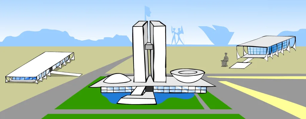
Brasília’s plan showcases time by presenting the nation with a single, legible stage. The Monumental Axis is a broad horizontal line that cuts straight across the plateau, bringing together ministries, museums, and monuments in a single parade. It reads like a calendar laid out on concrete and grass. During national holidays, as parades, air shows, and convoys proceed along the Esplanade where the ministries are located, the scale shifts from abstract to concrete. The route is simple enough for first-time visitors to understand at a glance: power advances toward the Three Powers Square (Praça dos Três Poderes), where decisions are transformed into a public theater.

What enables the axis to fulfill its function is the way it brings together the ceremony and daylight. In the cool morning hours, long shadows stretching from the ministry buildings create lines on the grass and transform the columns and piers into hour markers. In the late afternoon, the sun falls behind the TV Tower and Monumental Axis viewpoints, bathing the facades in a warm, even light that suits broadcast cameras and invites the crowd to linger. The city instinctively uses this daily rhythm—”official events in the morning, civil gatherings in the afternoon”—so that the same linear space can host both protocol and celebrations without altering its form.
The axis also serves as a national memorial route. Each building along the axis anchors a place and a function in the public consciousness: justice at one end, diplomacy behind the arched porticos, and the legislative branch crowned with twin bowls in the middle. When people return for Independence Day or the presidential inauguration, they do more than attend an event; they re-watch a familiar sequence. This repetition is the essence of calendar urbanism. Year after year, the city teaches itself where to look when the state speaks.

Yönetişimin Mekânsal Ritüelleri
Brasília’daki hükümet koreografi gibi hareket eder. Başkanlık göreve başlama töreni, konvoyla başlar, Katedral’in beton “tacının” önünden geçer, yemin töreni için Ulusal Kongre’ye girer ve ardından sembolik kuşağın takılması töreni için meydanı geçerek Planalto Sarayı’na gider. Her geçiş “sokaktan salona, salondan balkona” yasal bir adımı mekansal bir ana dönüştürür. Plan, sırayı anlaşılır kıldığı için halk, bunun nerede gerçekleştiğini izler.


Even ordinary weeks have their rituals. Cabinet meetings draw staff to the Esplanade in the cool of the morning, while the flag ceremony held on the first Sunday at Three Powers Square draws families who see it as a kind of civic sunrise ceremony. Protests and vigils planned for the cooler hours of the afternoon gather beneath the same facades and ramps where state ceremonies take place. The city’s openness invites gathering without disruption; there is no need to ask where the march will end, as the plan already provides the answer.
These habits make the capital city predictable in the best sense. Predictability is not rigidity; it is trust. When a vote or commemoration ceremony is scheduled on the calendar, the city can support it with clear transportation routes, broadcast viewing angles, and known security perimeters. People learn the timing—”when the shadows reach the grass, when traffic closures begin, when balcony doors open”—and participation becomes part of daily life.
Temporal Flow in Niemeyer’s Buildings
Oscar Niemeyer’s buildings transform time into motion. At Planalto and Alvorada, long ceremonial ramps replace staircases, so arrivals occur through measured glides rather than sudden steps. Speed is intentional; a figure ascending the white ramp becomes a human second hand sweeping across the dial, giving photographers and citizens the seconds they need to read the emotions on a face. Architecture sets the tempo of politics.
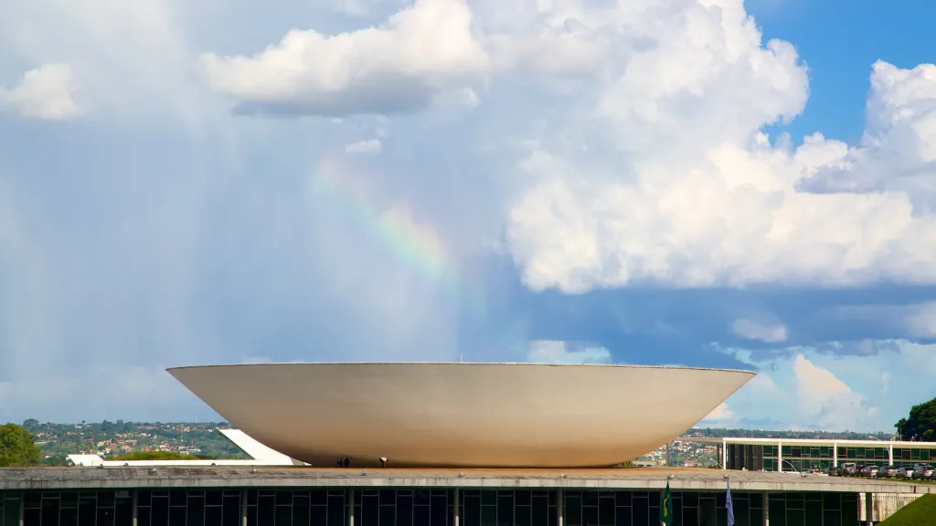
Light is another time keeper. Deep eaves, sunshades, and reflective pools soften Brasília’s high-sun climate, preventing interior spaces from becoming too bright. At the Itamaraty Palace, an archway formed by monumental arches surrounds a water garden that cools the air and extends reflections throughout the day. At the Congress, twin bowls—concave for representatives, convex for senators—capture the morning and evening sun differently, reminding observers that the two chambers, like the two halves of the day, must balance each other. Even when empty, these forms narrate a cycle.


The material helps the story unfold over hours and years. White concrete takes on subtle tones as the sky changes; polished stone darkens in storm light and shines brightly after rain. The city never looks exactly the same at two different moments, yet its main features remain constant. This constancy is comforting during long deliberations and nighttime votes. The rooms accept time, but do not allow the boundaries of institutions to blur.
How Does Programming Shape Civic Participation?
The capital’s calendars are drawn up with timing in mind, making it a design tool. Due to high temperatures and strong sunlight, most public events are shifted to the early morning and late afternoon hours, so public transportation schedules, shaded waiting areas, and water points are planned accordingly for these peak times. When an important vote or ceremony is held, road closures along the axis can be announced with minimal disruption; the long medians surrounding the parade routes also serve as a large overflow area for crowds and media vehicles.
The residential superblocks located slightly off the axis create a daily rhythm that sustains civilian life without overwhelming it. Workers can leave their offices on the Esplanade, relax in tree-lined courtyards, and return for evening meetings when the temperature drops. This rhythm aligns participation with ordinary routines. Parents can take their children to the flag-changing ceremony, office workers can attend rallies after work, and students can go from campus to a concert and then to a night shift along a single, understandable backbone.
Over time, the calendar becomes etched into the city’s muscle memory. People know the dates that belong to the entire nation and adjust accordingly. Shops open earlier, food stalls gather in familiar corners, and buses run at predictable intervals. Brasília proves that when you design a capital as a temporal tool, you reduce the friction of democracy. The program is no longer abstract. It becomes a walk, a slight angle, a ramp leading to a balcony, and the sound of the crowd arriving just in time.
Chichen Itzá: Architecture as an Astronomical Almanac
El Castillo and the Equinox Serpent
El Castillo functions like a stone theater for sunlight. Around the spring and autumn equinoxes, in the late afternoons, the northwest corner of the pyramid casts a series of triangular shadows onto the north staircase. These dark triangles merge with the carved serpent heads on the balustrade, forming a wavy “body” that appears to descend the stairs. Visitors experience this less as a calculation and more as a living moment: the square falls silent, the triangles sharpen, and a serpent appears, only to vanish as the sun sets. Scientists note that this effect can be seen for several weeks during each equinox, meaning it cannot be pinned down to a single day. Whether this effect was designed with the equinoxes in mind is debatable, but this event demonstrates how light, angle, and sculptures can come together to transform the sky into an artist’s canvas.


The geometry behind the display is simple and powerful. A stepped profile, a sharp corner, and a railing crowned with feathered serpent heads provide all the necessary elements for the shadow serpent. While its exact purpose may be debated, the design uses the repeatable movement of the sun to anchor a public ritual over time. Crowds still gather on these dates, proving that architecture’s calendar can be preserved in people’s minds as much as in stone.
Calendar Cycles in Pyramid Construction
The numbers have carved time into the shape of the building. Each side of El Castillo has approximately ninety-one steps; when these are added together and the top platform is counted as the final “step,” the total comes to three hundred sixty-five steps. One step for each day of the Maya civil year, Haab. The pyramid is a nine-tiered structure housing the Kukulcán temple, and its proportions allow us to perceive the stairs as measured paths throughout the year. Even accounting for erosion and reconstruction processes, this arithmetic is too clear to ignore: the stairs invite you to climb the calendar.

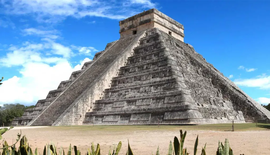
The monument is also layered over time. Excavations revealed an older temple within the pyramid, complete with a red jaguar throne and a chacmool statue. This nested structure shows that the building evolved as rituals and dynasties developed, while numerical clues continue to link the ceremony to the solar cycle. The result feels less like a single object and more like a palimpsest of calendars that have been rebuilt, re-ritualized, and reinterpreted over generations.
Chacmools, Rituals, and Solar Events
Chacmools are reclining stone figures holding a bowl or disk in their laps, and various offerings are made to these figures, ranging from incense and food to, in some cases, blood and human hearts. The example discovered in the substructure of El Castillo links the pyramid’s public solar drama to more intimate rituals where offerings timed according to seasonal changes were presented to a divine intermediary. In this way, the site’s calendar is not only visible from afar via the staircase but is also enacted on a human scale in a dark chamber where offerings meet the gods at designated times.
This duality of spectacle and presentation is compatible with a larger city. Nearby structures such as the Temple of Warriors and the Great Ball Court bring together crowds, sound, and sightlines; while the plaza becomes a shadow-dappled hour, the interior spaces host quieter ceremonies of petition and thanksgiving. The sun’s influence triggers gatherings in the open air and moves the ritual actors indoors, reinforcing the sense that the entire area operates according to a shared temporal narrative.
The Mayan Calendar in Written Form
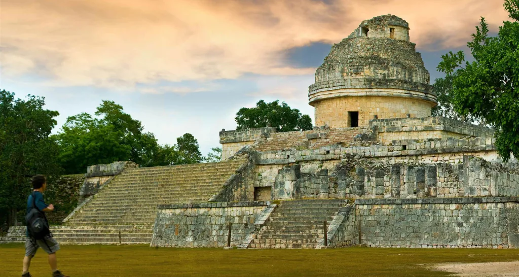
Chichen Itzá displays two different time measurement scales simultaneously. El Castillo encodes the solar year in steps and stages the equinoctial drama, while the circular tower of El Caracol, located elsewhere on the site, served observers tracking Venus’s eight-year super-cycles and other events through narrow window openings and sightlines. Together, they express a culture that reads the cycles of the sun, moon, and planets and fixes these rhythms onto walls, staircases, and landscapes, so that the city itself can remind people when to plant, fight, or celebrate.

In the Maya world, alignments typically mark sunrise and sunset dates separated by 13- and 20-day intervals, forming the “building blocks of the 260-day ritual count” and clustering around agriculturally significant seasons. This model helps explain why displays like the “serpent” are important beyond tourism: they belong to a larger observation calendar that synchronizes fields, markets, and ceremonies. At Chichen Itzá, Haab’, the ritual count, and the movements of Venus and the Sun do not just live in books; they live in the way the light meets the stone on specific days, transforming the architecture into an almanac you can walk through.